Update Odisha-Latest Odisha News I Breaking News Get latest news on Odisha, Govt. Jobs, OSSC, OPSC, Entertainment, Crime, Sports, and Education
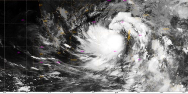
Bhubaneswar: The cyclonic storm taking shape over the Bay of Bengal is likely to cross the Odisha coast on the night of October 24, according to the Centre for Environment and Climate (CEC) of Siksha ‘O’ Anusandhan Deemed to be University here.
The landfall is expected to be somewhere in the coastal reaches of Kendrapara and Bhadrak districts, Dr. Sarat Chandra Sahu, Director of CEC, said.Meanwhile, the low pressure system which had formed over north Andaman Sea had intensified into a depression Tuesday morning and was moving in a west-northwesterly direction. It was centered about 700 km southeast of Paradip at 0830 hours on Tuesday, he said.
Its intensification will continue and it is expected to turn into a cyclonic storm over west-central Bay of Bengal in the evening of October 23, he said.The system is likely to move in a west-northwesterly direction for another 24 hours and thereafter take a northwesterly direction till it crossed the coast in the night of October 24.
Wind speed may touch 120 kmph in the sea in the afternoon of October 24 but its speed may get reduced to 85-110 kmph along the Odisha coast on the same night while crossing the coast.
In Bhubaneswar city and nearby areas the wind speed may be in the range of 55 to 70 kmph in the night of October 24 and 45-55 kmph in Berhampur on October 25 which will be felt till late evening.
Moderate to heavy rain will start in the evening or night of October 22 in the districts of Mayurbhanj, Balasore, Bhadrak and Keonjhar which will continue till the next day. Heavy to very heavy rain may occur from the afternoon of October 24 in the districts of Bhadrak, Jajpur, Kendrapara, Khurda, Cuttack, Puri, Nayagarh and Ganjam and continue till the afternoon of October 25, Dr. Sahu said.
After crossing Odisha coast, the system may get weakened and move in a south-southwesterly direction towards Koraput district causing rains in the south Odisha districts till October 26, he said.